Back جسر ويليامزبرغ Arabic Уилямсбъргски мост Bulgarian Pont de Williamsburg Catalan Williamsburg Bridge Czech Williamsburg Bridge German Puente de Williamsburg Spanish Williamsburgi sild Estonian Williamsburg zubia Basque پل ویلیامزبورگ Persian Williamsburg Bridge Finnish
Williamsburg Bridge | |
|---|---|
 | |
| Coordinates | 40°42′49″N 73°58′19″W / 40.71356°N 73.97197°W |
| Carries | 8 lanes of roadway 2 tracks of the Pedestrians and bicycles Streetcar tracks (until 1948) |
| Crosses | East River |
| Locale | Manhattan and Brooklyn, New York City |
| Maintained by | New York City Department of Transportation |
| ID number | 2240039[1] |
| Characteristics | |
| Design | Suspension bridge and truss causeways |
| Total length | 7,308 feet (2,227 m) |
| Width | 118 feet (36 m) |
| Longest span | 1,600 feet (490 m) |
| Clearance above | 10 feet 6 inches (3.2 m) (inner roadways only) |
| Clearance below | 135 feet (41 m) at mean high water |
| History | |
| Architect | Henry Hornbostel |
| Designer | Leffert L. Buck |
| Opened | December 20, 1903 |
| Statistics | |
| Daily traffic | 105,465 (2016)[2] |
| Toll | Free |
| Location | |
 | |
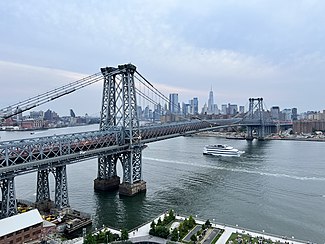
The Williamsburg Bridge is a suspension bridge across the East River in New York City, connecting the Lower East Side of Manhattan with the Williamsburg neighborhood of Brooklyn. Originally known as the East River Bridge, the Williamsburg Bridge was completed in 1903 and, at 7,308 feet (2,227 m) long, was the longest suspension bridge span in the world until 1924.
Proposed in January 1892, the bridge project was approved in 1895. Work began on June 19, 1896, under chief engineer Leffert L. Buck. Despite delays and funding shortfalls, the bridge opened on December 19, 1903. In addition to roads, walkways, and New York City Subway tracks, the bridge had four trolley tracks, which were replaced with roads in 1936 and 1949. The bridge underwent a substantial renovation in the 1980s and 1990s following the discovery of severe structural defects, and it was again being renovated in the 2020s.
The Williamsburg Bridge's main span is 1,600 feet (490 m) long and is carried on four main cables, which are suspended from two 335-foot (102 m) towers. Unlike similar suspension bridges, the side spans are supported by trusswork and additional towers. The 118-foot-wide (36 m) deck carries eight lanes of vehicular traffic, two subway tracks, and two walkway and bike paths that merge in Manhattan. The bridge is one of four free vehicular bridges between Manhattan Island and Long Island maintained by the New York City Department of Transportation, along with the Queensboro Bridge to the north and the Manhattan and Brooklyn bridges to the south. The bridge also serves as a connector highway to and from the Brooklyn-Queens Expressway (I-278) in Brooklyn.
- ^ Vulcan, Michele N. (2015). NYC DOT Bridges & Tunnels Annual Condition Report 2015 (PDF) (Report). New York City Department of Transportation. p. 167. Archived (PDF) from the original on February 1, 2017. Retrieved September 28, 2022.
- ^ "New York City Bridge Traffic Volumes" (PDF). New York City Department of Transportation. 2016. p. 9. Archived (PDF) from the original on March 11, 2018. Retrieved March 16, 2018.